General Information
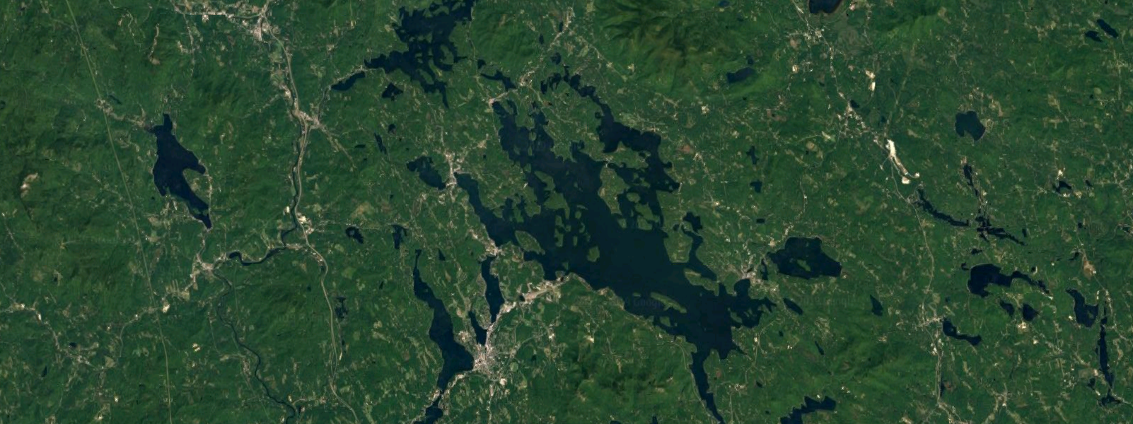
- Lake Winnipesaukee is the largest lake in the U.S. state of New Hampshire located in the Lakes Region. It is approximately 21 miles long and 9 miles wide, covering 69 square miles — 71 square miles when Paugus Bay is included — with a maximum depth of 180 feet.
- The lake contains at least 258 islands, half of which are less than a quarter-acre in size, and is indented by several peninsulas, yielding a total shoreline of approximately 288 miles. The driving distance around the lake is 63 miles. The lake is 504 feet above sea level. Winnipesaukee is the third-largest lake in New England after Lake Champlain and Moosehead Lake.
- There is a place for everyone on Lake Winnipesaukee to chart their own course for adventure and year-round fun. A quick 2-hour drive from Boston, Lake Winnipesaukee is truly a perfect getaway. As a popular summer destination, seasonal and permanent residents get to soak up the sun while sailing, kayaking, water-skiing, fishing, or simply lounging by the lake. Discover Lake Winnipesaukee from a high altitude while hiking West Rattlesnake Hill, Ossipee Mountain, or Belknap Range's many trails. Lake Winnipesaukee's many surrounding towns provide fine dining, local shops, and seasonal events. Even when the temperature drops, Lake Winnipesaukee provides the visitor with a variety of activities and winter sports. From hitting the slopes at Gunsmoke Mountain Resort to snowmobiling along the lakeshore, Lake Winnipesaukee is a four-season getaway.
- There are eight cities and towns that border Lake Winnipesaukee in New Hampshire - Alton, Center Harbor, Gilford, Laconia, Meredith, Moultonborough, Tuftonboro and Wolfeboro.
- The lake consists of a wide, relatively open central region known as the Broads, surrounded by several large bays, as well as many smaller inlets.
- The daytime speed limit for boats on the entire lake is 45 miles per hour.
- “The Witches” is a rocky area between Timber and Governor’s Islands. They are a group of extremely dangerous rocks that lies both below and just at the surface of the lake. They earned their name because they protrude from the lake like “Witches Hats”.
- Endicott Rock (housed in a small stone building near the channel at Weirs Beach) is named for John Endicott, Governor of Massachusetts Bay Colony and was at one time the northern most boundary of Massachusetts Bay Colony. The boundary was established in the summer of 1652. The Indian atop the monument is known as “Captain Jack”.
- The Winnipesaukee River flows out of Lake Winnipesaukee at the channel at Weirs beach, through Paugus Back, over a dam in the Lakeport area of Laconia, into Lake Opechee, and on to Lake Winnisquam.
- The main sections of the lake are:
- The Broads a wide portion of Lake Winnipesaukee largely in Belknap County and extending slightly into Carroll County. It is a large island-free zone occupying the center of the lake. Running along the main axis of the lake, the northwestern tip of the Broads is at the town of Center Harbor, while the southeastern end lies between the towns of Alton and Wolfeboro. The open nature of the Broads can lead to rougher water than the rest of the lake. Swells of 1-3 feet are not uncommon when winds top 10 miles per hour.
- Meredith Bay lies at the western edge of Winnipesaukee. At the northern tip of Meredith Bay is the main village of the town of Meredith. Meredith Bay is separated from the Broads by a relatively narrow strait bordered by Governors Island to the south and Stonedam Island to the north. The northeastern shore of Meredith Bay is a long peninsula known as Meredith Neck. Meredith Bay hosts the New England Pond Hockey Tournament and Ice Fishing Derby on the ice each winter.
- Paugus Bay branches off to the south of Meredith Bay at Weirs Beach, near to where Meredith Bay joins the main body of the lake. Formerly a hydrologically distinct lake, Paugus Bay became joined to Winnipesaukee when the dam at Lakeport was constructed, raising the surface of Paugus Bay to be contiguous with Winnipesaukee. Paugus Bay joins the main lake in Meredith Bay, running south from a narrow channel connecting it to Meredith Bay. At the northern end of Paugus Bay, where it joins the main lake, is Weirs Beach, the largest and most visited public beach on the lake. At the other end is the village of Lakeport. Both Weirs Beach and Lakeport are villages within the city of Laconia. The eastern shore of the bay is closely followed by U.S. Route 3, and has numerous motels, hotels, inns, and bungalow complexes. The western shore is much less developed.
- Alton Bay is a narrow bay which runs due south from the southern corner of the main lake. It lies entirely within the town of Alton. The village of Alton Bay lies at the extreme southern tip. The Alton Bay Seaplane Base is a state-owned, public-use seaplane base in Alton Bay, the southeast arm of the lake. In the winter it is the only FAA-approved ice runway in the contiguous United States, conditions permitting.
- Wolfeboro Bay is a relatively small wide bay lying in the town of Wolfeboro, creating a small northerly bulge in the shoreline to the eastern edge of Winnipesaukee. A series of smaller lakes and streams connects Wolfeboro Bay to Lake Wentworth.
- Winter Harbor is a Y-shaped bay with two branches, separated from the Broads by Wolfeboro Neck and Tuftonboro Neck. Winter Harbor is surrounded by many quiet resort communities in the towns of Wolfeboro and Tuftonboro. It also has panoramic views of the Belknap Mountains and looks out toward Rattlesnake Island.
- Moultonborough Bay is the longest bay on Winnipesaukee. It is connected to the Broads by some narrow straits running between a cluster of islands including Long Island (the largest island in the lake), Cow Island, Little Bear Island, Sandy Island, and dozens of smaller islands and islets. The 7-mile-long Moultonborough Neck separates the length of the bay from the main axis of the lake, and the Suissevale development in the town of Moultonborough is at the northern tip of the bay. Melvin Village, the main lakeside village of the town of Tuftonboro lies along the northeastern shore of the bay, closer to where it joins the Broads.
Indian Legend About Lake Winnipesaukee
There are two interpretations of Lake Winnipesaukee –
- "Beautiful Water in High Place”
- "The Smile of the Great Spirit" (most popular)
According to legend Lake Winnipesaukee in New Hampshire got its name with "The Smile of the Great Spirit" because of the love of two Indians. Here's the story:
Long ago a great chief, Wonaton, and his fair daughter, Mineola, lived on the northern shores of Lake Winnipesaukee. Mineola had many suitors but refused them all.
One day, a young chief, Adiwando, from an enemy tribe in the south paddled across the lake and entered the village. Natives from Wonaton's tribe saw his bravery and did not stop him.
Mineola and Adiwando fell in love and wanted to marry. Wonaton was angry and tried to kill Adiwando. Mineola rushed between them and begged her father to stop.
After they were wed, the whole tribe went in canoes to the middle of the lake. The skies were dark and as they began to leave, the sun came out around the canoe of Minola and Adiwando.
Wonaton thought it was a "good omen" and named the waters Lake Winnipesaukee or "The Smile of the Great Spirit."
Fun Facts on Lake Winnipesaukee In New Hampshire:
- It's the largest lake in New Hampshire.
- There are 240 miles of shoreline according to some; 183 miles according to others.
- There are 260 islands of many of which are habitable.
- Surface area is 72 square miles.
- The lake is 9 1/2 miles wide and 28 miles long.
- It is 504 feet above sea level.
- Deepest part of the lake - 169 feet, southeast of Rattlesnake Island. The rest of the lake is between 20 and 100 feet deep.
- Rattlesnake Island has the highest elevation of 400 feet.
- The route to drive around the lake from Meredith: Route 25 to Route 109 to Route 28 to Bay Hill. Road in Alton to Route 11 to Elm Street in Laconia to Parade Road (Route 106) to Route 3.
- Lake Winnipesaukee in New Hampshire freezes over early to mid-January.
- Facts on Ice Out - Official ice out is when the M/S Mount Washington can reach all four of its ports without touching ice.
- The Smallest Island - Becky's Island which is about 10 feet wide depending on water level.
- The Largest Islands - Long Island (which has a bridge to it) and Bear Island.
- Lake Winnipesaukee has three islands with the same name - all are called Loon Island.
- Nineacres Island actually has 13 acres.
- Stonedam Island has a wildlife preserve that can only be visited by boat.
- Lake temperature varies depending on the weather: A warm, sunny summer - up to 79; A cloudy, rainy summer holds the temperature between 67 and 74.
- Wolfeboro is the oldest summer resort town in the US.
- There are over 273 lakes and ponds in the lakes region of New Hampshire.
- Facts on the number of islands that can be reached by bridge - six; Black Cat Island, Long Island, Oak Island, Governor's Island, Worcester Island and Christmas Island.
- Islands measured from Center Harbor - Mile Island, Three-Mile Island, Five-Mile Island and Six-Mile island.
- Ossipee Mountains border Moultonboro on Lake Winnipesaukee.
- Wild animals in the Lake Winnipesaukee region: Otter, beaver, muskrat, mink, fisher, moose, deer, black bear, coyotes and bobcats.
- Loons return to Lake Winnipesaukee at ice out.
- There are 75 numbered buoys: 1-31 and 39-83.
- Navigating red and white buoys - proceed on the south and west side.
- Navigating the black and white buoys - proceed on the north and east side.
- Lakeport is the only dam that releases water from Lake Winnipesaukee. It is located at the southern end of Paugus Bay.
- Before the dam at Lakeport was built, the water level was 3-5 feet below what it is now.
- The area between Deven's Island and Little Bear Island is sometimes referred to as "Hole in the Wall."
- Birch Island and Steamboat Island are the only two islands connected by a bridge.
- "Sally's Gut" is a passageway for boats between Stonedam Island and Meredith Neck (mainland).
- "The Witches" is a rocky area of the lake east of Governor's Island. These rocks are normally just below the surface and extremely hazardous to boaters.
- Weirs Beach got its name from the native Indians. A long time ago, natives built a basket, call a weir, to catch fish (Shad) that migrated through the Weirs channel. The constant use of the weirs in the channel led to the name Weirs Beach.